


la chapelle v font urle

BELLETGE
User
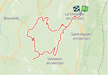

Length
47 km

Max alt
1466 m

Uphill gradient
1059 m
Km-Effort
61 km

Min alt
853 m

Downhill gradient
1059 m
Boucle
Yes
Creation date :
2023-08-21 06:18:04.103
Updated on :
2023-08-21 09:43:03.547
2h55
Difficulty : Medium

FREE GPS app for hiking
 SityTrail
IGN / Geographical institutes
SityTrail Plus
The world is yours!
About
Trail Road bike of 47 km to be discovered at Auvergne-Rhône-Alpes, Drôme, La Chapelle-en-Vercors. This trail is proposed by BELLETGE.
Positioning
Country:
France
Region :
Auvergne-Rhône-Alpes
Department/Province :
Drôme
Municipality :
La Chapelle-en-Vercors
Location:
Unknown
Start:(Dec)
Start:(UTM)
691612 ; 4982406 (31T) N.
Comments